Mapping of Rural Iowa Food Deserts
Mapping of Rural Iowa Food Deserts

Table of Contents
In December 2021, I started a four-month project of mapping rural food deserts in Iowa using the ArcGIS Pro software.
GOALS OF THE PROJECT
- To identify rural communities/areas in Iowa that are within a food desert.
- Create a map of those communities
- Present findings to key stakeholders who have the ability and resources to assist the identified food desert communities.
PROCESS
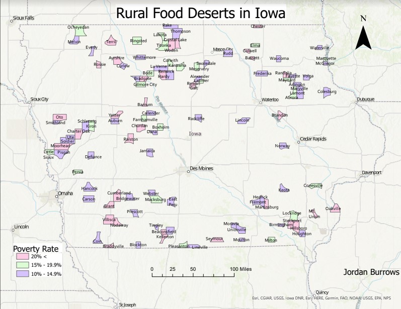
I first established the classification of a rural food desert based on the USDA definition: A community with a poverty rate greater than 10% and not within 10 miles of a wholesome food seller or pantry (excluding gas stations, fast food, etc.).
I began identifying all the chain grocery stores in Iowa which included HyVee, Walmart, Target, etc. I pinpointed all these stores onto a map and used a geoprocessing tool called a buffer, within the ArcGIS software, to create a 10-mile radius around each store location. This process created empty spaces on the map where a grocery store of any kind was not within 10 miles of a community.
The next step was to manually look into each of the empty spaces and identify the communities within those spaces. Of those identified communities, I researched poverty rates using US Census data to find those communities above the 10% poverty rate. I was then able to look into each community by using Google Street View to ensure they didn’t have a hometown grocery store that would not qualify them as a food desert.
RESULTS
The results of these efforts revealed that 111 total communities met the criteria to be classified as a rural food desert. That means over 41,500 Iowans are living in a community where there is no local access to wholesome food options.
On Tuesday, May 3rd I had the opportunity to present my project to 15 attendees of the Quad Cities Food Rescue Partnership (FRP) Stakeholder meeting via an online presentation. The FRP focuses on diverting food waste from landfills to people in need. The group was very impressed with my work and had many questions for me regarding the project. One attendee asked me what surprised me most when collecting the data, and I explained that I was most amazed by the number of food deserts identified and the likelihood that the number and size of the food deserts would/could expand if food banks and pantries were removed from a community. I provided them the PDF format of the rural food deserts in Iowa map to help them focus on communities in need of food donations or waste diversion programs and to use as a resource for any future projects.
I am excited to see that my project holds the potential to help those in need living in the rural food deserts.
- Jordan Burrows, Environmental Intern
My final goal of this project was to share my findings with stakeholders who can assist these food desert communities. The FRP was a great first step and I am looking forward to sharing my research with similar groups across the state of Iowa. I am excited to see that my project holds the potential to help those in need living in the rural food deserts.
FUTURE PLANS
I plan on expanding my project to urban food deserts, per the group’s suggestion, and attempt to correlate the identified food deserts to obesity, heart disease, and diabetes rates.


